Update 10/19 The Treasured Sugarloaf Landscape Management Plan is nearing a vote in Frederick County- here is a brief catch up on where things stand now.
There are two parts to the vote - the Plan and the Overlay are two different things. The Plan applies protections to the Sugarloaf region, the overlay is the actual zoning nuts and bolts that allow the plan's vision to be carried out - it establishes how permitting would work and disallows certain land uses (residential or ag are allowed things like gun ranges or rubble landfills, etc are not. )
October 18th was to be the vote on the overlay zone but that vote was delayed. Stronghold, the organization that owns Sugarloaf Mountain are threatening to close the mountain to the public should the overlay zone pass. Councilmembers seem to be bowing to this pressure and that is a shame.
Councilmembers supportive of the plan (which will deliver solid protections to the Sugarloaf region now that "carveouts" for developers intent on turning farmland into data centers have been removed) are now calling for a compromise that will keep the protective Resource Conservation (RC) zoning on most of the Mountain - keeping it's land use the same but passing the broader plan to protect the Sugarloaf region. The Frederick News Post has the latest. For full updates visit sugarloaf-alliance.org Stay Tuned!
The following is an important action alert from our friends at Sugarloaf Alliance.
Sugarloaf-Alliance.org
It’s Up To Each of Us!
Stop Data Center and Dense Development
Near Sugarloaf Mountain and Monocacy National Battlefield
PUBLIC HEARING on 9/27 at 5:30pm
Winchester Hall, 12 E Church St, Frederick
Come early!! Gather out front at 5PM.
On Tuesday, September 27, the Frederick County Council will hold their formal hearing on the Sugarloaf Plan and the amendments that have been introduced. This is the night when public comments are the primary focus of the meeting. An overflowing room of Sugarloaf preservation supporters, clad in green shirts*, will tell a story like nothing else can. Remember the gun range plan? Residents prevailed, and it was the overflowing Council space that made the difference. We need to do that again.
Why?
The Sugarloaf Treasured Landscape Management Plan is a once-in-a-generation plan to protect almost 20,000 rural acres in Frederick County - including Sugarloaf Mountain and the area around Monocacy National Battlefield - from dense residential, commercial, and potentially industrial development. Such development now threatens to cross from the east side of I-270 line to the rural west side.
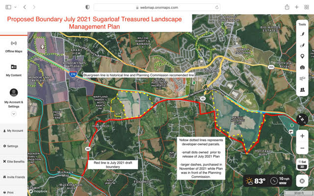
The current Sugarloaf Plan boundary (I-270) is opposed by an influential developer who owns over 600 acres in the Sugarloaf Plan area along the west side of I-270 near the Monocacy National Battlefield and Thurston Road. In the map below, the yellow dashed lines are developer property.
It’s Up To Each of Us!
Stop Data Center and Dense Development
Near Sugarloaf Mountain and Monocacy National Battlefield
PUBLIC HEARING on 9/27 at 5:30pm
Winchester Hall, 12 E Church St, Frederick
Come early!! Gather out front at 5PM.
On Tuesday, September 27, the Frederick County Council will hold their formal hearing on the Sugarloaf Plan and the amendments that have been introduced. This is the night when public comments are the primary focus of the meeting. An overflowing room of Sugarloaf preservation supporters, clad in green shirts*, will tell a story like nothing else can. Remember the gun range plan? Residents prevailed, and it was the overflowing Council space that made the difference. We need to do that again.
Why?
The Sugarloaf Treasured Landscape Management Plan is a once-in-a-generation plan to protect almost 20,000 rural acres in Frederick County - including Sugarloaf Mountain and the area around Monocacy National Battlefield - from dense residential, commercial, and potentially industrial development. Such development now threatens to cross from the east side of I-270 line to the rural west side.
The current Sugarloaf Plan boundary (I-270) is opposed by an influential developer who owns over 600 acres in the Sugarloaf Plan area along the west side of I-270 near the Monocacy National Battlefield and Thurston Road. In the map below, the yellow dashed lines are developer property.
Data Centers?
Sugarloaf Alliance has information from our public information requests that strongly suggests data centers have been under consideration for the developer's acreage
Data centers or any other dense development being considered there would cause irreversible damage to the Plan region. Constant noise, 24/7 lighting, enormous electrical and water demands, and monolithic buildings would cause serious reduction in property values, farming activities, natural resources, and rural life. Residents would move and - without the Plan - development would creep closer to Sugarloaf.
Council Member Dacey has proposed a Plan amendment that would re-draw the Plan boundary and remove 2,600 acres on the west side of I-270 from the Plan’s protection (the red line in the map above). That acreage includes the developer-owned property and rural properties near Monocacy National Battlefield. We believe it would be irresponsible and short-sighted to sacrifice these 2,600 rural acres to allow dense development here and pave the way for sprawl.
Proponents of development cite windfall revenues for the county, but Sugarloaf Alliance research shows that data centers offer few jobs. Unlike Virginia (“Data Center Alley” is in Ashburn), Maryland does not tax business personal property, including computers. The beneficiaries of intense development in the Sugarloaf Treasured Landscape would be in profits for non-resident developers and corporations.
What about Sugarloaf Mountain?
The board of the nonprofit organization (Stronghold, Inc.) that operates the 3,400-acre mountain also seeks exemptions from the Sugarloaf Plan. Members of the board have gone so far as to threaten to close the mountain to the public if they don’t get what they want.
Sugarloaf’s roads, trails, and picnic areas operate under a trust set up in the 1940s by Gordon Strong. The park has been a Registered Natural Landmark since 1969, and the trust preserves the mountain as a private park for the “benefit of the public.”
SHOW UP ON TUESDAY!
There’s no going back: If commercial interests prevail, if the Council does not hold the boundary line at I-270 and/or does not fully support the preservation overlay, the west-side sprawl will begin. The Sugarloaf Plan becomes a development plan, not a preservation plan. PLEASE ATTEND THE HEARING on 9/27!
* SUGARLOAF ALLIANCE HAS T-SHIRTS!
The Sugarloaf Alliance now has beautiful t-shirts, green of course! And perfect for supporting the Sugarloaf Plan on 9/27! You can get yours for a minimum donation of $20. We will have them in front of Winchester Hall on 9/27. If you like to get yours sooner, we’ll meet folks on SATURDAY, 9/24 between 10-11am, in the parking lot behind the Urbana Library (not the shopping center side).
The Sugarloaf Alliance represents over 500 stakeholders in the Sugarloaf region. The Alliance’s mission is to protect
the unique natural and historical aspects of the Sugarloaf Mountain area and its environment through education and
initiatives in support of watersheds, streams, meadows, forests, and historic sites. Working with volunteers, civic
groups, and local, state, and federal agencies, the organization’s primary goal is to preserve the unique character and
serenity of the area for future generations. Sugarloaf Alliance is a 501(c)(3) organization. Sugarloaf-Alliance.org
Steve Black, President
Sue Trainor, Vice President
Nick Carrera, Treasurer
Johanna Springston, Secretary