

Choose Your Route
We found a few lumpy spots to let you know about and one wayward sign at Willard and Westerly - plus free cold drinks for Reserve Riders. Check out these route hazards here.
Please note: These routes are for our "virtual riders" that are taking on a route at a time/day of their choosing. If you signed up for an in-person ride you are meeting your ride leader Vivien at a specific time and place and these routes do not apply. You should be getting emails from us with all the info - if not- please email [email protected] and she will get you sorted out.
|
Every route is a great ride past farms, along Rustic Roads. Here is more information on the stops, views and terrain to help you decide.
Moderately hilly routes of approximately 8, 12, 22, 28, 40 and 62 miles depart from Poolesville High School (17501 W Willard Rd, Poolesville, MD 20837). All routes offer beautiful scenery and stay mainly on quiet roads. All routes have a mile or two where the traffic is slightly heavier, such as Route 28 and Comus Road approaching Sugarloaf Mountain, but even there, the traffic isn't overwhelming. There are no bike paths or trails on these routes. There will be no spray painted arrows or signs. A majority of these are on rustic roads.
A Few Notes:
A word on timing: The earlier in the day you go, the less traffic you'll encounter. This is key for weekends and any routes near Sugarloaf (routes of 28 miles and longer). Specifically, after noon on weekends the Sugarloaf Winery has many folks driving on Comus road.
|
Oh, Hello Sugarloaf!
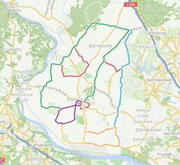
click to see all the routes on a map on Ride with GPS
|
- The full collection of routes can be found on Ride With GPS Right Here this is the best way to view all routes together to decide which one works for you, clicking on each one allows you to see the terrain and elevation. You may also want to check out which routes hit which open farms by taking a look at the stops page. You can of course visit farms after your ride as well.
- 62 miles- GPS Here /Cue Sheet This is it - the Metric Century.
- 40 miles - GPS Here / Cue Sheet A ride up to Sugarloaf Country and then looping back down toward the Potomac and up toward Poolesville.
- 28 miles - GPS Here / Cue Sheet A ride along Peach Tree Rd and its orchards then up to Sugarloaf Country
- 22 miles - GPS Here / Cue Sheet Two loops south and east of Poolesville to Rocklands Farm and back.
- 12 miles - GPS Here / Cue Sheet South of Poolesville, along the river and back up to town.
- 8 miles - GPS Here / Cue Sheet Head out of town for quiet roads with few climbs.
(Novice riders are encouraged to try one of the shorter routes)
**Routes subject to minor updates due to changes in road conditions. We recommend waiting until shortly before the event to download GPS files and cue sheets. Please keep checking your email as we will alert you to any hazards we find as we check over the routes.**
**Routes subject to minor updates due to changes in road conditions. We recommend waiting until shortly before the event to download GPS files and cue sheets. Please keep checking your email as we will alert you to any hazards we find as we check over the routes.**