The County Council wants to allow commercial scale solar on "less productive" class 3 soils. What can be grown on class 3 soils? How about next generation of MoCo's sustainable table crop producers - if they don't have to compete with commercial scale solar for land. (Pictured here: Farmer Jared moved from MA to found Wildflower Farm on a few leased acres of class 3 soils in Dickerson found through our Land Link program. There are currently 34 more farmers looking for land in the program. Since 2011 we've matched 500 acres of land...and counting)
What's Happening:
If commercial scale solar is allowed in the County's Ag Reserve on otherwise productive farmland, it will take this land out of commission for current and future table crop producers in the only part of the county set aside for agriculture. Time is fleeting to take action, please take two minutes to do so here (even if you already have) before 7pm on 7/21.
If commercial scale solar is allowed in the County's Ag Reserve on otherwise productive farmland, it will take this land out of commission for current and future table crop producers in the only part of the county set aside for agriculture. Time is fleeting to take action, please take two minutes to do so here (even if you already have) before 7pm on 7/21.
ZTA 20-01 - a push for commercial scale solar siting on up to 3 square miles (1800) acres of the the County's Agricultural Reserve- has been a controversial proposal from the start. Reasonable people can agree that regenerative energy needs to be scaled up to meet the challenge of our lifetime (climate change) but disagree about where these commercial uses should be sited and the protections required for existing natural systems.
At first this ZTA had no protections for habitat/forest/water quality or productive soils - in the area set aside for the protection of these things - the Ag Reserve. Councilmembers Jawando and Friedson offered amendments to try to put some of these protections in as the complex and controversial proposal was inexplicably speeding through committee despite concern from urban rural residents and unanimous opposition from the farming community.
The second T+E (Transportation and Environment Committee) hearing took place on July 16 (full wrap up here). County staff had prepared a GIS map that showed how many acres remained for industrial solar if it were prohibited on fragile lands of different types - slopes, forests, stream buffers.
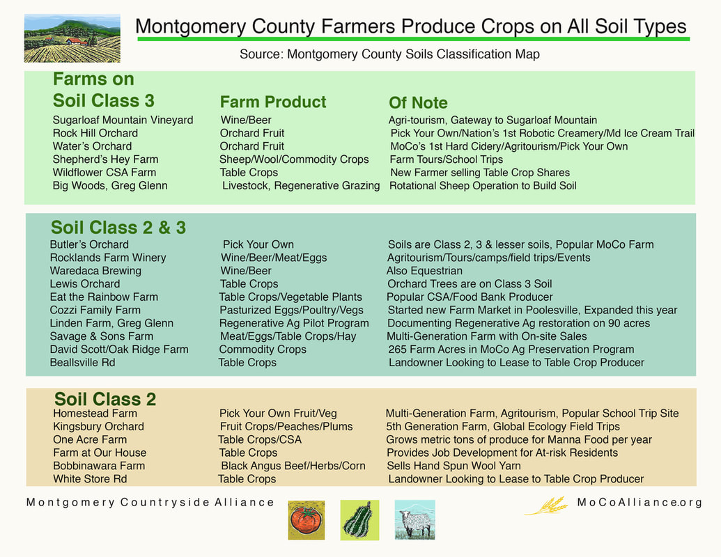
Once the forests, buffers and slopes where taken out, then Councilmembers had to learn more about the difference between prime soils and the different classifications of soils 1-3. Jeremy Criss of Ag Services said that for the Ag Preservation program they do not use the "prime" designation but instead focus on classes 1-3 as "productive".
Seeing that taking out all soils 1-3 (again, all called "productive") would leave only 3000 acres where industrial solar could be sited seemed to frustrate ZTA architect Councilmember Hans Riemer - "well, it just isn't worth doing if you take all this land out of consideration - solar providers will have to find a needle in a haystack". Riemer would rather protect soils by capping the number of acres that can be under solar as a way to protect farms. To which Councilmember Friedson said, "It's not how much solar we want, it is where we want it. There are consequences."
Watching the hearing, the map of soils looked like a sea of colors - there was no on-the-ground nuance provided about what the different classes of soil look like and what they can grow- the consequences for failing to protect soils Friedson so rightly pointed out. This does a disservice to the discussion and the decision makers having it.
That is why we at MCA did a bit of digging (sorry;)) and correlated the Reserve's farms to the types of soils they possess to better show the impact of this proposal. See the list of which farms are on which soil below or click here to see it bigger.
At first this ZTA had no protections for habitat/forest/water quality or productive soils - in the area set aside for the protection of these things - the Ag Reserve. Councilmembers Jawando and Friedson offered amendments to try to put some of these protections in as the complex and controversial proposal was inexplicably speeding through committee despite concern from urban rural residents and unanimous opposition from the farming community.
The second T+E (Transportation and Environment Committee) hearing took place on July 16 (full wrap up here). County staff had prepared a GIS map that showed how many acres remained for industrial solar if it were prohibited on fragile lands of different types - slopes, forests, stream buffers.
Once the forests, buffers and slopes where taken out, then Councilmembers had to learn more about the difference between prime soils and the different classifications of soils 1-3. Jeremy Criss of Ag Services said that for the Ag Preservation program they do not use the "prime" designation but instead focus on classes 1-3 as "productive".
Seeing that taking out all soils 1-3 (again, all called "productive") would leave only 3000 acres where industrial solar could be sited seemed to frustrate ZTA architect Councilmember Hans Riemer - "well, it just isn't worth doing if you take all this land out of consideration - solar providers will have to find a needle in a haystack". Riemer would rather protect soils by capping the number of acres that can be under solar as a way to protect farms. To which Councilmember Friedson said, "It's not how much solar we want, it is where we want it. There are consequences."
Watching the hearing, the map of soils looked like a sea of colors - there was no on-the-ground nuance provided about what the different classes of soil look like and what they can grow- the consequences for failing to protect soils Friedson so rightly pointed out. This does a disservice to the discussion and the decision makers having it.
That is why we at MCA did a bit of digging (sorry;)) and correlated the Reserve's farms to the types of soils they possess to better show the impact of this proposal. See the list of which farms are on which soil below or click here to see it bigger.
An on the ground example - the intersection at 28 and Peach tree road as seen by the Councilmembers on the map in the hearing vs Google satellite view is instructive:
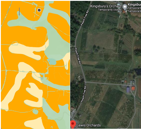
At left - blobs of color:
Orange= Class 2 soils
Peach=Class 3 soils
Green= higher/ "worse" than class 3
At right, the same view on Google Satellite view of two legacy table crop producing farms, Kingsbury's Orchard to the North and Lewis Orchard to the South. The blocks of dark green in the lower part of the google map (on those class 3 soils) are rows upon rows of table crops grown by Lewis Orchard, farming since 1888. From the ground it looks like this (Lewis Orchard Facebook):
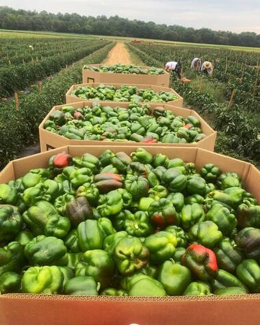
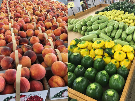
A small sampling of the 25+ crops they grow look like this:
Why this matters:
Most Reserve farms are growing bountiful local table crops on soils 2 and 3 and "worse". We are looking to grow the next generation of farmers in MoCo. In our expensive region, land leases are the way to get new farmers started. All our Land Link matches in the Reserve so so far are on mixed class 2, 3 and worse soils. The landowners offering land for lease in the Reserve have the same 2/3+ soils. Under this ZTA, the landowner could either site an industrial use on that acreage or lease to a new table crop producer in the only part of the county set aside 40 years ago for that purpose. All "productive" soils class 1-3 need to be protected under this ZTA so that Agriculture can be protected in the Agricultural Reserve.
Most Reserve farms are growing bountiful local table crops on soils 2 and 3 and "worse". We are looking to grow the next generation of farmers in MoCo. In our expensive region, land leases are the way to get new farmers started. All our Land Link matches in the Reserve so so far are on mixed class 2, 3 and worse soils. The landowners offering land for lease in the Reserve have the same 2/3+ soils. Under this ZTA, the landowner could either site an industrial use on that acreage or lease to a new table crop producer in the only part of the county set aside 40 years ago for that purpose. All "productive" soils class 1-3 need to be protected under this ZTA so that Agriculture can be protected in the Agricultural Reserve.
What's Next?
The Committee will again meet on this issue at 9:30am on Wednesday (7/22) - click here to watch on YouTube.
If you have not yet let the Council know your concerns - take two minutes to do so here- we thank you!
The Committee will again meet on this issue at 9:30am on Wednesday (7/22) - click here to watch on YouTube.
If you have not yet let the Council know your concerns - take two minutes to do so here- we thank you!